
Mountains in Pakistan: The Beasts
8000+ Meter Mountains in Pakistan
Pakistan is a land of breathtaking natural beauty, with towering peaks and snow-capped mountains that rise high above the rest of the landscape. These peaks are not only a source of awe and inspiration for those who gaze upon them, but they also offer some of the most challenging and rewarding climbing experiences in the world. In this article, we will take a closer look at the top peaks of Pakistan and the unique characteristics that make them so special. Here are the list of mountains in Pakistan that are both 8000+ meters and 7000 to 8000 meters.
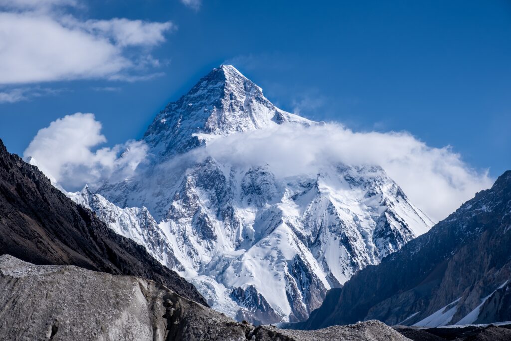
K2; the Highest Mountain of Pakistan
K2, also known as Mount Godwin-Austen, is the second highest peak in the world, standing at a towering 8,611 meters (28,251 feet) above sea level. This peak is located in the Karakoram range, which is situated in the northern region of Pakistan and spans into China and India. K2 is widely considered to be one of the most difficult and dangerous peaks to climb, with a fatality rate of around 25%. Despite its reputation, K2 continues to draw climbers from around the world who are looking for a truly challenging and rewarding experience.
One of the most notable features of K2 is its steep and rugged terrain. The peak is surrounded by massive glaciers and ice fields, making it a particularly challenging climb for even the most experienced mountaineers. The peak also experiences extremely high winds and storms, making it even more difficult to navigate. The first successful ascent of K2 was made by an Italian team in 1954, but it was not until 1977 that a team of climbers reached the summit without the use of supplementary oxygen.
We have an amazing helicopter tour of K2 for that you can book and enjoy the most stunning views.
Nanga Parba
Nanga Parbat, also known as the “Killer Mountain”, is the ninth highest peak in the world, standing at 8,126 meters (26,660 feet) above sea level. This peak is located in the western Himalayas, in the northern region of Pakistan. Nanga Parbat is known for its steep and rocky terrain, which makes it a difficult climb even for experienced mountaineers. The peak is also known for its unpredictable weather, which can change quickly and without warning, making it even more challenging to navigate.
Nanga Parbat was first climbed in 1953 by an Austrian team, led by Hermann Buhl. Despite its reputation as a dangerous peak, Nanga Parbat continues to attract climbers from around the world who are looking for a challenging and rewarding climbing experience. In recent years, the peak has also become a popular destination for trekkers and hikers, who come to enjoy the breathtaking views and stunning natural beauty of the surrounding landscape.
You can enjoy the stunning views of Nanga Parbat with our helicopter tour of Nanga Parbat.
Discover Fairy Meadows and enjoy the stunning views of Nanga Parbat
Gasherbrum
Gasherbrum I, also known as K5, is the eleventh highest peak in the world, standing at 8,080 meters (26,510 feet) above sea level. This peak is located in the Karakoram range, in the northern region of Pakistan. Gasherbrum I is known for its steep and icy terrain, which makes it a challenging climb even for experienced mountaineers. The peak is also known for its unpredictable weather, which can change quickly and without warning, making it even more difficult to navigate.
The first successful ascent of Gasherbrum I was made by an American team in 1958. Despite its reputation as a difficult and dangerous peak, Gasherbrum I continues to attract climbers from around the world who are looking for a challenging and rewarding climbing experience. The peak is also popular with trekkers and hikers, who come to enjoy the breathtaking views and stunning natural beauty of the surrounding landscape.

Broad Peak
Broad Peak, also known as K3, is the twelfth highest peak in the world, standing at 8,051 meters (26,414 feet) above sea level. This peak is located in the Karakoram range, in the northern region of Pakistan.
is known for its broad and gentle summit, which is relatively easy to climb compared to other peaks in the Karakoram range. However, the peak is still challenging due to its remote location, unpredictable weather, and the risk of avalanches. The first successful ascent of Broad Peak was made by an Austrian team in 1957.
Broad Peak is a popular destination for climbers and trekkers, as it offers a relatively easy climb with stunning views of the surrounding peaks. The peak is also popular with mountaineers who are looking for a less challenging climb while still being able to experience the thrill of climbing in the Karakoram range.
Rakaposhi
Rakaposhi, also known as Raka, is the twenty-seventh highest peak in the world, standing at 7,788 meters (25,551 feet) above sea level. This peak is located in the Karakoram range, in the northern region of Pakistan. Rakaposhi is known for its steep and rocky terrain, which makes it a challenging climb even for experienced mountaineers. The peak is also known for its unpredictable weather, which can change quickly and without warning, making it even more difficult to navigate.
The first successful ascent of Rakaposhi was made by an Italian team in 1958. Despite its reputation as a difficult and dangerous peak, Rakaposhi continues to attract climbers from around the world who are looking for a challenging and rewarding climbing experience. The peak is also popular with trekkers and hikers, who come to enjoy the breathtaking views and stunning natural beauty of the surrounding landscape.
Enjoy amazing view of Rakaposhi and discover Hunza Valley with out tour.
7000 to 8000 Meters Mountains in Pakistan
Pakistan is home to some of the world’s highest peaks, including several that exceed 7,000 meters in elevation. These peaks are located in the Karakoram and Himalayan mountain ranges, and offer some of the most challenging and rewarding climbing experiences in the world.
Gasherbrum III
Gasherbrum III, also known as Hidden Peak or Gasherbrum Faqir, is a 7,952 meter peak located in the Karakoram range of Pakistan. It is the 11th highest peak in Pakistan and the 22nd highest in the world.
The peak is situated in the Gasherbrum massif, which is a group of peaks that includes Gasherbrum I and II, and Broad Peak. The massif is located in the Baltoro Glacier region, which is known for its stunning glaciers and peaks.
Gasherbrum III was first climbed by a German-Austrian team in 1957, and since then, it has become a popular destination for mountaineers. However, it is still considered a challenging climb, with steep and technical terrain, as well as unpredictable weather conditions.
Climbing Gasherbrum III typically takes several weeks, with climbers having to acclimatize to the high altitude before attempting the summit. The standard route to the summit is via the southwest face, which is a steep and technical climb that requires the use of ice axes and crampons.
The best time to climb Gasherbrum III is in the summer months of June to August, when the weather is generally more stable and the snow conditions are favorable. However, even during these months, the weather can be unpredictable, and climbers should be prepared for extreme conditions.
Overall, Gasherbrum III is considered a challenging and rewarding climb, and is a must-do for experienced mountaineers looking for a challenging and remote adventure in Pakistan’s Karakoram range.
Gasherbrum IV
Gasherbrum IV is a peak located in the Karakoram range of Pakistan, with an elevation of 7,932 meters. It is the 13th highest peak in Pakistan and the 25th highest in the world. It is located in the Gasherbrum massif, which is a group of peaks that includes Gasherbrum I and II, Broad Peak, and Gasherbrum III.
The first ascent of Gasherbrum IV was made by an Austrian expedition in 1958, and since then, it has become a popular destination for mountaineers. However, it is still considered a challenging climb, with steep and technical terrain, as well as unpredictable weather conditions.
Climbing Gasherbrum IV requires a high level of skill and experience, as well as a good physical condition. The standard route to the summit is via the southeast face, which is a steep and technical climb that requires the use of ice axes and crampons. The climb typically takes several weeks, with climbers having to acclimatize to the high altitude before attempting the summit.
The best time to climb Gasherbrum IV is in the summer months of June to August, when the weather is generally more stable and the snow conditions are favorable. However, even during these months, the weather can be unpredictable, and climbers should be prepared for extreme conditions.
Overall, Gasherbrum IV is a challenging and rewarding climb, and is a must-do for experienced mountaineers looking for a challenging and remote adventure in Pakistan’s Karakoram range. Climbing this peak requires a permit from the Pakistan Alpine Club and should be done with a local guide or with a reputable climbing agency.
Distaghil Sar
Distaghil Sar is a 7,885 meter peak located in the Karakoram range of Pakistan. It is the 15th highest peak in Pakistan and the 29th highest in the world. It is located in the Hispar Glacier region, which is known for its stunning glaciers and peaks.
Distaghil Sar was first climbed by a German-Austrian team in 1960, and since then, it has become a popular destination for mountaineers. However, it is still considered a challenging climb, with steep and technical terrain, as well as unpredictable weather conditions.
Climbing Distaghil Sar typically takes several weeks, with climbers having to acclimatize to the high altitude before attempting the summit. The standard route to the summit is via the southeast face, which is a steep and technical climb that requires the use of ice axes and crampons.
The best time to climb Distaghil Sar is in the summer months of June to August, when the weather is generally more stable and the snow conditions are favorable. However, even during these months, the weather can be unpredictable, and climbers should be prepared for extreme conditions.
Overall, Distaghil Sar is considered a challenging and rewarding climb, and is a must-do for experienced mountaineers looking for a challenging and remote adventure in Pakistan’s Karakoram range. As with all peaks in Pakistan, climbing Distaghil Sar requires a permit from the Pakistan Alpine Club and should be done with a local guide or with a reputable climbing agency.
Masherbrum
Masherbrum, also known as K1, is a 7,821 meter peak located in the Karakoram range of Pakistan. It is the 17th highest peak in Pakistan and the 31st highest in the world. It is located in the Baltoro Glacier region, which is known for its stunning glaciers and peaks.
Masherbrum was first climbed by a British-Pakistani team in 1960, and since then, it has become a popular destination for mountaineers. However, it is still considered a challenging climb, with steep and technical terrain, as well as unpredictable weather conditions.
Climbing Masherbrum typically takes several weeks, with climbers having to acclimatize to the high altitude before attempting the summit. The standard route to the summit is via the southwest face, which is a steep and technical climb that requires the use of ice axes and crampons.
The best time to climb Masherbrum is in the summer months of June to August, when the weather is generally more stable and the snow conditions are favorable. However, even during these months, the weather can be unpredictable, and climbers should be prepared for extreme conditions.
Overall, Masherbrum is considered a challenging and rewarding climb, and is a must-do for experienced mountaineers looking for a challenging and remote adventure in Pakistan’s Karakoram range. As with all peaks in Pakistan, climbing Masherbrum requires a permit from the Pakistan Alpine Club and should be done with a local guide or with a reputable climbing agency.
Batura I
Batura I is a 7,785 meter peak located in the Karakoram range of Pakistan. It is the 18th highest peak in Pakistan and the 34th highest in the world. It is located in the Batura Glacier region, which is known for its stunning glaciers and peaks.
Batura I is a part of the Batura massif, which is a group of peaks that includes Batura II (7,795m), Batura III (7,766m) and Batura IV (7,589m).
Batura I was first climbed by a Japanese expedition in 1976, and since then, it has become a popular destination for mountaineers. However, it is still considered a challenging climb, with steep and technical terrain, as well as unpredictable weather conditions. The approach to the peak is particularly difficult, as it involves crossing the Batura Glacier, which is known for its crevasses and avalanches.
Climbing Batura I typically takes several weeks, with climbers having to acclimatize to the high altitude before attempting the summit. The standard route to the summit is via the southwest face, which is a steep and technical climb that requires the use of ice axes and crampons.
The best time to climb Batura I is in the summer months of June to August, when the weather is generally more stable and the snow conditions are favorable. However, even during these months, the weather can be unpredictable, and climbers should be prepared for extreme conditions.
Overall, Batura I is considered a challenging and rewarding climb, and is a must-do for experienced mountaineers looking for a challenging and remote adventure in Pakistan’s Karakoram range. As with all peaks in Pakistan, climbing Batura I requires a permit from the Pakistan Alpine Club and should be done with a local guide or with a reputable climbing agency.
Kanjut Sar
Kanjut Sar is a 7,760 meter peak located in the Karakoram range of Pakistan. It is the 19th highest peak in Pakistan and the 35th highest in the world. It is located in the Hispar Glacier region, which is known for its stunning glaciers and peaks.
Kanjut Sar was first climbed by a Japanese expedition in 1977, and since then, it has become a popular destination for mountaineers. However, it is still considered a challenging climb, with steep and technical terrain, as well as unpredictable weather conditions.
Climbing Kanjut Sar typically takes several weeks, with climbers having to acclimatize to the high altitude before attempting the summit. The standard route to the summit is via the southwest face, which is a steep and technical climb that requires the use of ice axes and crampons.
The best time to climb Kanjut Sar is in the summer months of June to August, when the weather is generally more stable and the snow conditions are favorable. However, even during these months, the weather can be unpredictable, and climbers should be prepared for extreme conditions.
Overall, Kanjut Sar is considered a challenging and rewarding climb, and is a must-do for experienced mountaineers looking for a challenging and remote adventure in Pakistan’s Karakoram range. As with all peaks in Pakistan, climbing Kanjut Sar requires a permit from the Pakistan Alpine Club and should be done with a local guide or with a reputable climbing agency.
Saltoro Kangri
Saltoro Kangri is a 7,742 meter peak located in the Karakoram range of Pakistan. It is the 20th highest peak in Pakistan and the 36th highest in the world. It is located in the Saltoro Mountains, which is known for its remote and rugged terrain.
Saltoro Kangri was first climbed by a Japanese expedition in 1977, and since then, it has become a popular destination for mountaineers. However, it is still considered a challenging climb, with steep and technical terrain, as well as unpredictable weather conditions. The peak is located in a remote region, and the approach to the mountain involves crossing glaciers and negotiating difficult terrain.
Climbing Saltoro Kangri typically takes several weeks, with climbers having to acclimatize to the high altitude before attempting the summit. The standard route to the summit is via the northwest face, which is a steep and technical climb that requires the use of ice axes and crampons.
The best time to climb Saltoro Kangri is in the summer months of June to August, when the weather is generally more stable and the snow conditions are favorable. However, even during these months, the weather can be unpredictable, and climbers should be prepared for extreme conditions.
Overall, Saltoro Kangri is considered a challenging and rewarding climb, and is a must-do for experienced mountaineers looking for a challenging and remote adventure in Pakistan’s Karakoram range. As with all peaks in Pakistan, climbing Saltoro Kangri requires a permit from the Pakistan Alpine Club and should be done with a local guide or with a reputable climbing agency.
Tirich Mir
Tirich Mir is a 7,708 meter peak located in the Hindu Kush range of Pakistan. It is the highest peak in the Hindu Kush range and the 21st highest peak in Pakistan. It is located in the Chitral district, which is known for its stunning glaciers and peaks.
Tirich Mir was first climbed by a Swiss expedition in 1950, and since then, it has become a popular destination for mountaineers. However, it is still considered a challenging climb, with steep and technical terrain, as well as unpredictable weather conditions. The peak is located in a remote region, and the approach to the mountain involves crossing glaciers and negotiating difficult terrain.
Climbing Tirich Mir typically takes several weeks, with climbers having to acclimatize to the high altitude before attempting the summit. The standard route to the summit is via the west face, which is a steep and technical climb that requires the use of ice axes and crampons.
The best time to climb Tirich Mir is in the summer months of June to August, when the weather is generally more stable and the snow conditions are favorable. However, even during these months, the weather can be unpredictable, and climbers should be prepared for extreme conditions.
Overall, Tirich Mir is considered a challenging and rewarding climb, and is a must-do for experienced mountaineers looking for a challenging and remote adventure in Pakistan’s Hindu Kush range. As with all peaks in Pakistan, climbing Tirich Mir requires a permit from the Pakistan Alpine Club and should be done with a local guide or with a reputable climbing agency.
Chogolisa I
Chogolisa I, also known as K2 West, is a 7,665 meter peak located in the Karakoram range of Pakistan. It is the 22nd highest peak in Pakistan and the 39th highest in the world. It is located in the Concordia region, which is known for its stunning glaciers and peaks.
Chogolisa I is part of the Chogolisa massif, which is a group of peaks that includes Chogolisa II (7,659m) and Chogolisa III (7,611m). The massif is located near the famous K2 peak, and it’s often referred to as the “sister peak” of K2.
Chogolisa I was first climbed by an Italian expedition in 1974, and since then, it has become a popular destination for mountaineers. However, it is still considered a challenging climb, with steep and technical terrain, as well as unpredictable weather conditions. The approach to the peak is particularly difficult, as it involves crossing the Chogolisa Glacier, which is known for its crevasses and avalanches.
Climbing Chogolisa I typically takes several weeks, with climbers having to acclimatize to the high altitude before attempting the summit. The standard route to the summit is via the northwest face, which is a steep and technical climb that requires the use of ice axes and crampons.
The best time to climb Chogolisa I is in the summer months of June to August, when the weather is generally more stable and the snow conditions are favorable. However, even during these months, the weather can be unpredictable, and climbers should be prepared for extreme conditions.
Shispare
Shispare is a 7,611 meter peak located in the Hindu Kush range of Pakistan. It is the 23rd highest peak in Pakistan and the 40th highest in the world. It is located in the Chitral district, which is known for its stunning glaciers and peaks.
Shispare was first climbed by a German-Austrian expedition in 1977, and since then, it has become a popular destination for mountaineers. However, it is still considered a challenging climb, with steep and technical terrain, as well as unpredictable weather conditions. The peak is located in a remote region, and the approach to the mountain involves crossing glaciers and negotiating difficult terrain.
Climbing Shispare typically takes several weeks, with climbers having to acclimatize to the high altitude before attempting the summit. The standard route to the summit is via the west face, which is a steep and technical climb that requires the use of ice axes and crampons.
The best time to climb Shispare is in the summer months of June to August, when the weather is generally more stable and the snow conditions are favorable. However, even during these months, the weather can be unpredictable, and climbers should be prepared for extreme conditions.
Overall, Shispare is considered a challenging and rewarding climb, and is a must-do for experienced mountaineers looking for a challenging and remote adventure in Pakistan’s Hindu Kush range. As with all peaks in Pakistan, climbing Shispare requires a permit from the Pakistan Alpine Club and should be done with a local guide or with a reputable climbing agency.
Silberzacken
Silberzacken is a 7,573 meter peak located in the Karakoram range of Pakistan. It is the 24th highest peak in Pakistan and the 41st highest in the world. It is located in the Baltoro Glacier region, which is known for its stunning glaciers and peaks.
Silberzacken was first climbed by a German-Austrian team in 1984, and since then, it has become a popular destination for mountaineers. However, it is still considered a challenging climb, with steep and technical terrain, as well as unpredictable weather conditions.
Climbing Silberzacken typically takes several weeks, with climbers having to acclimatize to the high altitude before attempting the summit. The standard route to the summit is via the southwest face, which is a steep and technical climb that requires the use of ice axes and crampons.
The best time to climb Silberzacken is in the summer months of June to August, when the weather is generally more stable and the snow conditions are favorable. However, even during these months, the weather can be unpredictable, and climbers should be prepared for extreme conditions.
Overall, Silberzacken is considered a challenging and rewarding climb, and is a must-do for experienced mountaineers looking for a challenging and remote adventure in Pakistan’s Karakoram range. As with all peaks in Pakistan, climbing Silberzacken requires a permit from the Pakistan Alpine Club and should be done with a local guide or with a reputable climbing agency.
Trivor
rivor Peak is located in the Hispar Muztagh subrange of the Karakoram range in the Shimshal Valley of Gilgit-Baltistan, Pakistan. It is considered to be a challenging climb due to its high altitude and remote location. The peak is popular among experienced mountaineers and climbers. The Shimshal Valley is also known for its natural beauty and trekking opportunities.
Diran
Diran Peak is a mountain located in the Nagar Valley of Gilgit-Baltistan, Pakistan. It is part of the Central Karakoram range and has an elevation of 7,266 meters (23,835 feet). The peak is considered to be a challenging climb due to its high altitude and steep terrain. It was first summited in 1960 by a team of climbers from Austria. The peak is popular among experienced mountaineers and climbers. The surrounding area is also known for its natural beauty and trekking opportunities.
In conclusion, Pakistan is home to some of the most awe-inspiring peaks in the world, each with its unique characteristics and challenges. From the towering height of K2 to the broad summit of Broad Peak, these peaks offer a range of climbing experiences for mountaineers of all skill levels. Whether you are a seasoned climber or a trekker looking for a breathtaking view, Pakistan’s peaks are sure to take your breath away. These peaks not only offer a great climbing experience but they also provide an opportunity to explore the beauty of nature and to understand the importance of preservation of such natural assets.


